Sky’s the limit!

Sky’s the limit!
Drone program at Harbor Springs High School really takes off.

February 2021 – Rob LaPoint’s drone class at Harbor Springs High School started four years ago as a way to show students the novice abilities of piloting unmanned aerial vehicles. Since then, it has grown to encompass so much more, opening up a sky’s-the-limit amount of potential future opportunities to the students enrolled.

Screen Shot 2021-02-09 at 11.13.21 AM.png

When it comes to careers that utilize drone technology, each year seems to bring new avenues for their use: estimating excavation site material volume; deliveries of goods; energy industry applications; real estate photography; search-and-rescue operations; surveying; archeology; topographical mapping; logging; and infrastructure examination, such as power poles and roofs – to name just a few.

“What Rob has done for this program is incredible. He sees the opportunities this brings to students and the potential for what is to come,” said Jim Rummer, Director of Career and Technical Education for Char-Em ISD. While the UAV program is not a state-certified CTE program yet, it likely will be soon. Rummer has been advocating at the state level by demonstrating the vast career doors that can open for licensed drone pilots – and it’s close to becoming a reality.

“I expect in the next year that this program will be a state-certified CTE program, which will open up so many more opportunities for funding and opportunities, including the flow of our Char-Em ISD CTE millage dollars to the class,” said Rummer. “And on a state level, we will be proud to note that we are among the first class of its kind.”

LaPoint looks forward to the official state designation as he continues to reach out to contacts locally and Michigan-wide to grow his own skills in order to teach his students. For instance, he credited Kurtis Damerow with Emmet Drones for helping him become trained in various drone models. “If it wasn’t for him, we wouldn’t even be close to where we are at today,” LaPoint noted, adding on that particular day Damerow was coming in to class to show them how to do power pole inspections.

Students are catching on to the excitement, too, as their own skills grow.

“I have flown remote-controlled devices from a young age, so I just thought it would be fun,” said Josiah Chamberlin, a 12th grader. “Now I realize that it is a skill that is in demand all over the world.”

LaPoint and Rummer drive that point home regularly in conversations about unmanned vehicles, both above water (UAVs) and underneath it (ROVs). Char-Em ISD’s annual summer camp, Career Academy for Kids, has featured a drone program introducing both types of vehicles to young students. To further illustrate the program’s growth, this year students from Harbor Springs Middle School are being bused to Harbor High to take a STEM class, Basics of Aeronautics, to hopefully ignite their interest in the high school program and, ultimately, careers.

“What we are trying to accomplish is to show students that these are good-paying, in-demand careers that can take them anywhere in the world,” LaPoint said. “I think the message is getting through.”

The message is indeed getting across. Senior Robbie Gillette said the class opened his eyes to a career path after high school. “I would like to do oil field inspections or other jobs (using drone technology) on weekends to earn money if I decide to pursue a different route,” Gillette said.

Safety and skills go hand-in-hand

A big part of LaPoint’s classes center on safety. In fact, students are able to take a safety exam from the Unmanned Safety Institute (USI) at no charge to the student, which, while not required to legally fly drones, goes a long way toward pursuing post-secondary degrees or professional operation. Students can also take the Federal Aviation Administration (FAA) drone piloting test and become FAA-certified drone pilots in high school. These testing opportunities provide cost savings to the student, as the fees for USI and FAA testing are covered by Char-Em ISD. And both provide a big boost toward a career utilizing drones.

Several students from LaPoint’s class have passed the FAA exam already with flying colors. Some have gone on to study further at Northwestern Michigan College in Traverse City, which operates one of the premiere drone programs in the region and state. Others have used their skills to land summer jobs, while others continue to ponder how they might use the lessons they are learning as 10th through 12th graders.

Jason Slade, Director of Technical Academic Area at NMC, said the Harbor Springs program is unique in part because LaPoint was an early adopter of drone technology in the classroom.

“While drone applications in STEM and CTE classrooms are growing, Rob was on the forefront and has been the most progressive. His class gives students insight into the current and future applications of drone technology. In addition, those skills are transferable to a number of other industries as the same skills can be applied to marine applications and more,” said Slade. “We hope in the future other schools will use the Harbor Springs program as a springboard to start their own drone or unmanned systems program or add drones into an existing program. We are hopeful the collaborative grant we are working on with Char-Em will help with this.”

Slade said students from Harbor who have gone on to attend NMC’s Engineering Technology – Unmanned Aerial Systems (UAS) / Drone Specialization have been well-prepared.

“First, many enter the program with their FAA Part 107 Drone license, which allows you to safely operate a drone for all non-recreational purposes. This certification is articulated into our program which gives the student credit for one of our UAS classes, saving them time and money!” Slade said. “This credit is part of Engineering Technology – UAS degree (AAS, 2-year) and the UAS pilot certificate. It is only awarded because of what occurs in the HSHS classroom.”

More than adept at passing tests, Slade said the students show impressive competencies across the board.

“They are up-to-date on the latest drone technology and on piloting drones. Just as importantly, they are skilled troubleshooters and are competent with system integration. Once they enter our program, we add additional skills including electronics, programming, microcontrollers, advanced drone operations and then a capstone / project course that brings it all together,” Slade noted.

Funding and support boosts program

Last year, AT&T awarded the program $14,000 to purchase equipment, which LaPoint used to buy some impressive gear like Phantom 4 RTK drones for 3D mapping and volume calculations.  

It’s one example of how community and organizational support continues to grow for the program. Students have been able to participate in real-life practices as well, such as using their drones and software to estimate volume of materials for Harbor Springs Excavating, and inspect roofs and power lines for the city. A few of the students’ experiences have landed them part-time summer job offers from area businesses. 

Support for the program has resulted in LaPoint being able to use the latest technology for his students. A Parrot Anafi Thermal drone lets them practice roof (and home) inspections, and general heat loss. The Mavic/Phantom 4/Inspire 1 gives the students the chance to inspect power poles, practice general photography and videography.

With Harbor High School being home to a swimming pool, LaPoint and Rummer foresee growing the program to include an ROV – Remotely Operated Vehicles – that operate underwater. Once again, a host of career opportunities await those skilled in ROV operations.

“Rob is an instructor who continues to go above and beyond to make things happen for kids,” said Rummer.

For some students, having fun has gone hand-in-hand with the learning. Domitien Dante Boda, a 12th-grader, said it’s not likely he will pursue a career in drone work, but “I still want to fly drones and play around with them, as long as I follow the regulations.”

Senior Luke Baker said he enrolled in the class because it seemed fun, and in the process learned “how to think critically under pressure and how to evaluate risk.”

For that reason, Slade, the NMC director, said the class is preparing students for whatever their future might bring.

“The skills they are learning can be applied to so many applications and systems. We will see drone technology morph and change over the coming years. However, the problem-solving, integration, and technical skills they are learning can be applied to so many jobs and industries,” Slade added. “It is an exciting time to be involved in this technology and any field related to STEM.”    

Sourced from www.charemisd.org

Using Drones as a Tool to Drive Public Engagement

Landscape architects and planners have relied on Unmanned Aircraft Vehicles (UAVs or drones) for site analysis, monitoring construction progress and benchmarking projects in recent years. Data and birds-eye imagery from drones can even enhance storytelling to bolster community engagement and deepen the clarity and communication of design ideas.

Recent studies have shown that the average human attention span is eight seconds and falling, according to National Center for Biotechnology Information. The way in which people gather information is in short segments through push notifications on smart devices, social media, and text messages with the average webpage visit lasting under a minute—most leaving a page within 10-20 seconds. This creates a challenge for planners and designers who depend on stakeholder input to drive the design process. In a world saturated with digital stimuli, designers need to leverage tools to make the most of the eight second attention span. This requires visual storytelling techniques that are clear, concise, and entertaining. While webpage visits are short, the average length of a video watched is 2.7 minutes. This creates an opportunity to employ drone technology in the community and stakeholder engagement process. As designers tasked with translating stakeholder desires into a built product, it is critical that our communication methods reflect the way people consume information, particularly when social distancing regulations are in place and feedback is obtained virtually.

Topography and birds-eye imagery captured by drone technology is used to quickly iterate multiple alternatives and help to clearly communicate design ideas. Image courtesy of Design Workshop.

Topography and birds-eye imagery captured by drone technology is used to quickly iterate multiple alternatives and help to clearly communicate design ideas. Image courtesy of Design Workshop.

A New Workflow for Cycling Ideas

Planners and landscape architects at Colorado-based Design Workshop have been doing just that. By utilizing drone footage collected as part of the site analysis for two St. Louis area projects – Alton Great Streets and Frenchtown Great Streets, the team saw the opportunity to represent the complex relationships of the proposed plan concepts by combining drone footage, 3D modeling and time-based media. Lidar data along with birds-eye imagery captured by drones served as a basis for draping proposed AutoCAD linework to quickly iterate multiple alternatives. Incorporating drone topographic data and imagery with AutoCAD platforms and 3D rendering software allows designers to produce videos that clearly communicate the intent and context of proposals. The drone imagery serves as an ideal base for these graphics because of the viewers ability to quickly recognize place and context, while the 3D topographic model allows the proposals to accurately align with the perspective of the drone imagery. The creation of short video clips allowed the team to add movement and emotion as part of the graphics, rather than relying on an analog plan or static rendering. By embedding videos of approximately two minutes into a short online survey, the team was able to achieve more than double the participation than in-person meetings — a critical metric to achieve during the COVID-19 pandemic, particularly when future federal and state funding will require public support for the plans.

Overcoming Challenges

While the new drone-captured images and video were well-received by community members and proved to effectively achieve the team’s goals, it was still a challenging process. The current technology that designers and planners must use has a steep learning curve and requires a significant investment of time. The other challenge to consider is equitable access. Not every person has access to computer, smart device or internet making it necessary to think about how you provide offline access to the same information. Hosting public meetings (when allowed to), making hard-copy images available and finding ways to display project options in public settings must occur in tandem with any digital execution of ideas to ensure all have the opportunity to share their feedback.

A Tool to Enhance the Stakeholder Engagement Process

While overlaying proposed plans with drone footage and integrating time-based media to share via a virtual survey and via social media served the same purpose as a public meeting in the extenuating circumstances brought on by COVID, it isn’t meant to be a replacement. These communications tools can and should be used along with traditional community meetings by ensuring clear communication of proposals, and allowing for more time to actually engage, cycle ideas, and build partnerships — enabling more two-way and collaborative communication to occur — ultimately leading to a plan that best serves the community. Videos make input methods more engaging, tactile, entertaining, accessible, and comprehensible. These methods result in better participation and ultimately, more likely implementation.

Sara Egan is an associate with Design Workshop and serves as a landscape architect and certified planner. Maddie Clark is a project landscape designer at Design Workshop. Founded in 1969, Design Workshop is an international design studio integrating landscape architecture, urban design, economics and engagement.

By Sara Egan and Maddie Clark

Sourced from Mile High CRE

Drones Survey Power Lines in High-Risk Fire Areas

In addition to foot patrol crews, trucks and helicopters, drones are used to inspect electrical equipment in high fire-risk areas.Photo by Ernesto Sanchez.

In addition to foot patrol crews, trucks and helicopters, drones are used to inspect electrical equipment in high fire-risk areas.Photo by Ernesto Sanchez.

If you combine the states of New York, Delaware and Rhode Island, then you would have an area roughly the size of the total service territory of 50,000 square miles for Southern California Edison (SCE). And all the electrical equipment throughout this area needs to be inspected regularly.

In areas designated by the state as having a high risk for wildfires, SCE has poles, transformers and lines that number about 400,000. To inspect this equipment for any needed repairs, the utility uses foot patrol crews, trucks and helicopters. And now you can add drones to this list of tools.

“We are trying to mobilize every asset we have to get power back on quickly and safely. And that includes drones,” says Tom Guntrip, SCE director of Transportation Services, who noted that drones can be deployed locally, especially in rural and mountainous areas. “Drones have to be part of our arsenal of tools.”

Investing in Drones

In 2015, SCE bought its first drone. Now, it has 20 drones with high-tech capabilities, including infrared, that help capture detailed images of infrastructure often in remote, hard-to-reach locations. SCE has about 15 FAA-licensed and company-trained drone operators, and that number is increasing. The utility also uses contractors.

The drones were originally brought on to enhance the utility’s equipment inspection capabilities. That original intent has remained the same with added focus on those areas with a high risk for wildfires. Drones are also being piloted for possible use during Public Safety Power Shutoffs to safely and quickly inspect lines so power can be safely restored to customers.

All SCE drone operators are required to follow SCE’s stringent confidentiality policies and procedures. SCE drone operators comply with all FAA regulations, including not flying near or in an active wildfire unless special authorization has been obtained from authorities in the interest of the public.

“When we first got the drones, it was like a moon landing. No one here had done it before, but we had to get it right the first time,” says Craig Stenberg, SCE Air Operations Remote Sensing manager and a former Navy combat air crew member. “Our goal is to enhance the inspection procedure and drones are an efficient means to access difficult-to-reach infrastructure.”

Assisting With Helicopter Inspections

Helicopters are often deployed for equipment inspections over a large geographic area. Drones are quieter and can be used in sensitive areas where helicopters may create undue disturbance. Drones can also get more detailed images and videos since they are able to fly in closer to the infrastructure.

Helicopter pilots spend years training to fly safely, but a drone operator can be trained within a matter of weeks. Linemen can also use a drone — mounting cameras on the top or bottom of the device — to help inspect equipment without having to climb a pole, making it safer.

“Drones are the future, especially the inspections part of it,” says Stenberg, noting that drones can also be used to string lines in some cases instead of a helicopter, helping to save money. “Drones can get closer to what you want to inspect making it much easier to identify which structures are being inspected.”

Drone footage is downloaded, and SCE inspectors look for equipment that needs repairs. Once needed repairs are identified, crews and helicopters are scheduled for deployment. SCE’s Digital and Process Transformation group is now working to develop software that can more quickly analyze the images from the drones using Artificial Intelligence and Machine Learning.

An image taken from a drone of an SCE power pole. Photo by Roberto Lazerte.

An image taken from a drone of an SCE power pole. Photo by Roberto Lazerte.

In addition to using drones in equipment inspections, SCE is training drone operators throughout the company, including in its environmental sciences group that helps ensure endangered animals and plants are unharmed during any utility work.

“Drones are another tool to enable a greater understanding of our grid and with this information we can make the remediation safer and more quickly,” says Guntrip. “Drones help us look at the state of our infrastructure.”

Taking Safety Inspections to the Next Level

Though also widely used in utility equipment inspections and wildfire mitigation efforts, drones have quickly become an essential tool for SCE in its dam safety inspections too.

SCE has 83 dams in its hydroelectric system stretching from Catalina Island to Big Creek near Fresno, California. In addition to safer and more cost-effective inspections, drones help SCE’s hydro team maintain the dams safely and effectively.

“The drones have been a powerful tool, and I think we can do a lot more going forward,” says Nicolas von Gersdorff, SCE’s chief dam safety engineer.

Monitoring Remote Areas

Drones’ advantage over helicopters includes better control over the height to the structure, letting it get up close and personal while still having a bird’s eye view.

Future use of the drones includes FAA approval to fly outside the line of sight — which the FAA doesn’t yet allow—as well as the use of Artificial Intelligence and Machine Learning.

As is, the Dam & Safety group’s two Parrot Anafi drones — operated by two FAA and SCE Air Operations-authorized pilots observing the utility’s strict confidentiality policies and procedures—have greatly enhanced inspections of remote, difficult-to-access dams, efficiently delivering high-resolution images that identify minor issues like leakages and cracks before they become major problems. Images that Patrick Le, one of the drone operators and an SCE engineer, said are further enhanced through technologies like LiDAR and 3D mapping.

“Drones are just an excellent tool with speed, safety and practicality,” says Le of the unmanned aerial vehicles used for dam inspections since 2016. “We get measurable data and a bird’s eye view.”

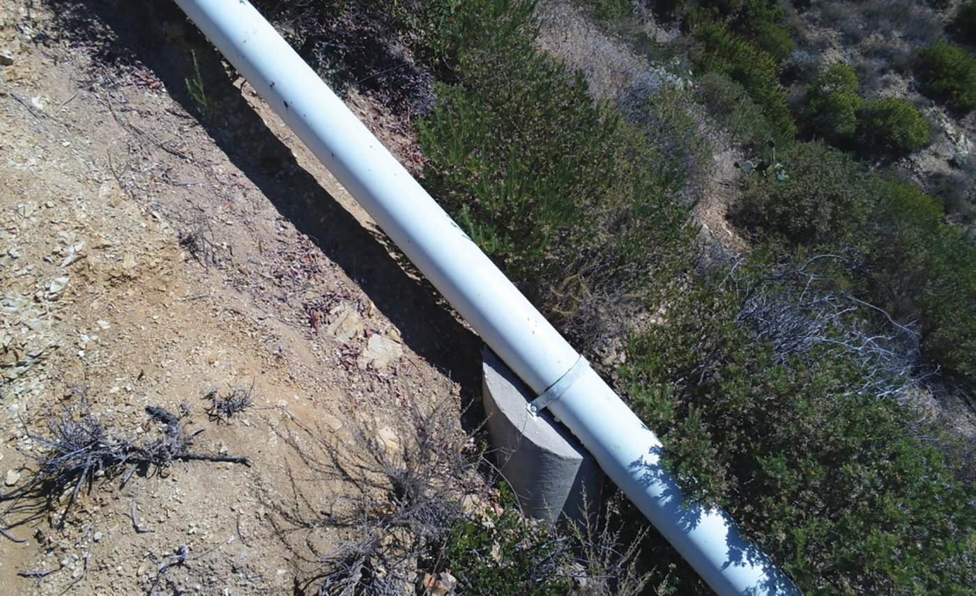
Drones can easily inspect pipelines in hard-to-reach areas, reducing expense and safety hazards.

In the winter, that data can come through as thermal imaging of powerhouses’ penstock pipes. This speed and capability is important when SCE needs to manage near-record snow in the system. And Le and his group are intrigued by LiDAR analysis and Structure from Motion, saying, “We essentially stitch a series of photos together in a 3D model to get something you can’t get with a typical visual inspection. Sometimes you can capture things you can’t see with the naked eye.”

Drones can easily inspect pipelines in hard-to-reach areas, reducing expense and safety hazards, even in winter when thermal imaging can be used.

Drones can easily inspect pipelines in hard-to-reach areas, reducing expense and safety hazards, even in winter when thermal imaging can be used.

Reducing Risks

Even more crucial are the drones’ elimination of the safety risks involved in worker inspections that require specialized equipment and training to physically access steeply sloped areas of a structure.

And, amid the COVID-19 pandemic, SCE’s Meg Richardson pointed out another unexpected bonus.

“Just looking at where we are with present times and COVID-19, inspections can be done via drone now instead of having people go out in groups,” said Richardson, an SCE senior advisor in Regulatory Affairs and Compliance. “I think it’s also a way to be innovative for what the future might look like.”

Le, an SCE engineer who started flying this drone last year, calls it safer and more effective because of the quality of data delivered without putting anyone in harm’s way.

Surveillance cameras, like the drones, also provide improved and continuous situational awareness of dams that can take hours to reach on difficult and snow-swept roads. The team finds the cameras particularly useful during earthquakes like those experienced within the last year in the area.

“We pulled up the camera and getting that immediate feedback is tremendously valuable,” says von Gersdorff. “We have emergency action plans for all our dams and what we see from case studies is that the timing is so essential in improving our emergency response capabilities.”

Together, the high-tech drones and cameras present opportunities galore for the Dam & Safety team to continue enhancing safety and inspections.

“Technology like this sets forth that we can be better prepared because we are being innovative with the technology out there,” Richardson says. “We’re continuing to look at innovation on how to meet regulatory requirements as well as additional ways this technology can be used in what will be the new normal. It’s definitely a highlight.”

Editor’s Note: This article combines two stories, which first appeared on EnergizedbyEdison.com.

Sourced from: T&D World

Why Drones are a Great Solution for Inspecting 1.4 Million Utility Poles in Southern California

Photo: Roberto Lazarte

Photo: Roberto Lazarte

Electricity provider Edison is turning to drones to inspect its electrical equipment across Santa Barbara County’s south coast. The company began with helicopters, but is likely to switch to drones after the end of the week.

The company has begun using helicopters and drones to regularly inspect its equipment in high fire-risk areas. Both the drones and helicopters fly during the day to cut down on noise and get better images of the equipment.

Edison has 1.4 million utility poles, making it a costly and time-consuming job, not to mention the danger associated with flying a helicopter near live wires. Local residents have reported the low-flying inspection helicopters, forcing the Santa Barbara County Sheriff’s Department to put out a public notice:

We have received several reports of low-flying helicopters over Carpinteria and Montecito — they are contract surveyors for Southern California Edison.

Looking at the above issues with helicopters, it all points to drones being a great replacement. The drones keep workers on the ground. Using drones also lowers long-term costs.

Drones currently only make up around 25% of the inspections done by Edison, with the other 75% being completed by helicopters. A few years ago, this number was less than it is now. This is an exciting time to be working with drones as it’s a transition period to a new way of doing things. David Song from Edison noted that drones can get into nooks and crannies helicopters aren’t able to.

Sourced from: DroneDJ

Drone Businesses Become More Specialized

By Evan Jones | February 28, 2020 | Capital News Service

LANSING — Many drone pilots who started a business to provide photo and video services to clients of all types now are specializing. 

People who operate drones for profit traditionally have shot footage of a house in the morning and a wedding in the afternoon, according to Andrew Wolfe, the pilot-in-command of Drone Brothers, a Troy company that specializes in serving construction and real estate companies.

Anyone can buy a drone but to make money from it, the Federal Aviation Administration  requires pilots to receive certification, Wolfe said.

The improved quality of imagery from drone cameras has made demand rise across many sectors of the national economy, such as agriculture and infrastructure development, Wolfe said.

“When you zoom in on Google, you get to a certain level, it gets pixelated and you can’t really see clear images,” Wolfe said. 

“With the drone, when you fly over a piece of land, it goes back and forth like a lawnmower and captures hundreds or thousands of pictures, and we use a specialized software to stitch those pictures together to give someone a bird’s-eye view of what that property looks like,” he said.

But the market viability for catch-all drone services may be fading away, he said.

“There are so many opportunities with the drones,” Wolfe said. “We kind of realized early that we really need to narrow down our focus.”

Kurtis Damerow, the owner of Emmet Drones in Petoskey, agrees that the market for all-services drone businesses is saturated.

“There is still some room, but the level of competition is huge,” he said. “If you’re looking to build a large business, you either have to know a lot of people or you’re going to have to hustle really, really hard.” 

Damerow spent the past year in California learning how to map and inspect power lines for utility companies, a skill he hopes to bring back to Michigan. 

Michigan’s utilities haven’t made drone inspections a priority yet, but services that companies like his  provide could be the norm within five years, Damerow said. 

“At the end of the day, it helps them complete better inspections for less money. I think it’s a no-brainer,” he said. 

The rate of advancement in technology requires specialization in the industry, Wolfe said.

“As time goes on, these drones are getting smarter and smarter, literally. Literally on a quarterly basis there’s new updates for software,” he said. 

Drones collect so much data that it can quickly become overwhelming, said Corey Oeschger, who started Thumb Drone Works in Bay Port in 2012 with a majority of clients in agriculture.

“It’s getting kind of hard to keep up with it,” he said. “We try to stay on the cutting edge of technology with sensors and the drones themselves.” 

Oeschger said he started the business hoping the drone would pay for itself.

“I thought ‘well, I could charge people for taking pictures of their farms,’” he said. “It kind of just went crazy from there.”

Drone technology has rapidly developed and is now transitioning from updates of the hardware itself to the software and accessories attached to drones, Oeschger said.

“I kind of had to make a choice a long time ago to keep up with the industrial technology, or go into taking neat pictures,” Oeschger said. “A friend of mind does the same thing. He’ll spend hours to take 200 pictures just for one good one, and I just don’t have the patience or the time for that.” 

Drones are evolving at the rate computers did, which could cause the industry to grow exponentially, Oeschger said.

“The computer was the size of a building. Now obviously there are homes that have more computing power than the space shuttle,” he said. 

As for drones, “They’re changing almost daily, the stuff that’s coming out software-wise. I’m looking forward to the next five to 10 years.”

Sourced from msu.edu.

Drones effective tools for fruit farmers

A researcher from the Idaho research team physically scouts the orchard. Drones can cover several times more area in a day than a human, with high quality, consistent data for farmers. Credit: Esmaeil Fallahi.

A researcher from the Idaho research team physically scouts the orchard. Drones can cover several times more area in a day than a human, with high quality, consistent data for farmers. Credit: Esmaeil Fallahi.

January 8, 2020 – People have used the phrase “drone on and on” for a long time. Webster’s dictionary defines this figure of speech as “to speak for a long time in a dull voice without saying anything interesting.”

Yet, in agriculture, drones aren’t dull, at all!

Farmers use drones to be more efficient. Drones help farmers improve yields and stay ahead of problems before they become too big.

Olga Walsh, University of Idaho, is researching the use of drones for fruit trees. Most of the agricultural applications for drones - or, more technically unmanned aerial vehicles (UAV) - have been on grain crops like wheat, corn and soy.

“Adoption and use of crop sensors in production agriculture saves thousands of dollars every year in many crops,” says Walsh. “Crop sensors also help to significantly improve the efficiency of agricultural inputs, such as fertilizers and water. Finally, drones can minimize negative impacts of agricultural activities on environmental quality.”

In Idaho, the fruit industry grows grapes, cranberries, apples, and even alternative fruits like Asian pears. Apples are the largest fruit crop in Idaho, with over 60 million pounds of apples produced per year.1

Walsh’s research team focused on applying UAV technology to fruit trees. Her previous work has been with wheat and other crops. “We know drones can be used in orchards,” says Walsh. “But there aren’t any grower recommendations regarding what data needs to be collected and what kind of data is most useful, depending on the grower objective.”

The most promising ways the drones could be employed for the orchards and tree nurseries are:

  • taking inventory of tree height and canopy volume;

  • monitoring tree health and quality;

  • managing water, nutrients, pests and disease in-season;

  • estimating fruit/nut production and yield; and,

  • creating marketing tools (videos for promotion of the orchard, or sale of trees and fruit).

Like with other uses of drones in agriculture, Walsh’s work helps to collect detailed information about the crops, faster than humans could by physically “scouting” the fields. “The UAVs are capable of acquiring images with high resolutions that are ideal for detecting various crop issues,” says Walsh. “The UAV systems allow scanning the crops from above. They obtain high quality images and high-resolution spectral data. This is correlated with plant growth, health, water and nutrient status, and can be used to estimate biomass production.” All are indicators of potential yield.

It’s not just about the speed of scouting a field. “Sensors can function within regions of the electromagnetic spectrum where human eyes can’t,” says Walsh. “Sensors are much more reliable and objective than visual assessment. They provide quantitative information (numeric data that can be measured and compared) versus qualitative information (descriptive data that can be observed).”

Team members also perform outreach. “We conduct grower education on the use of remote sensing and using UAVs for crop monitoring,” says Walsh. “We do demonstration flights and produce publications to boost grower adoption of precision agriculture methods.”

“The overall goal of this work is to strengthen sustainability and competitiveness of Idaho fruit tree producers,” says Walsh. “Our findings increased awareness, knowledge, and adoption of crop sensors and UAVs.”

And, that’s not dull at all!

Walsh presented her work at the November International Annual Meeting of the American Society of Agronomy, Crop Science Society of America, and Soil Science Society of America in San Antonio. Funding for this project came from the Idaho State Department of Agriculture Nursery Advisory and Florist Advisory Committee.

1. https://agri.idaho.gov/main/about/about-idaho-agriculture/idaho-crops/

Sourced from capitalpress.com.

NYC Lawmakers Pushing To Overturn 1948 Law, Allow Drones To Do Building Inspections

NEW YORK (CBSNewYork) — City officials are backing a plan to allow drones to inspect buildings.

The move comes after an architect was tragically killed last week by falling facade from a building in Midtown, CBS2’s Dave Carlin reported Sunday.

“We need to get creative,” Councilman Justin Brannan said.

Some city council members want to lift building inspections in New York City to new heights.

They want to check for problems by air — not with helicopters, but with things much smaller.

“The city needs to embrace drone technology,” Brannan said.

Bills are in the works to mandate timely drone checks.

“It would require Department of Buildings to conduct an initial drone inspection within 48 hours of a 311 complaint or a DOB violation,” Brooklyn Borough President Eric Adams said.

The push to fast track the proposals are coming as a result of Tuesday’s falling debris death of architect Erica Tishman, as she walked on West 49th Street near Seventh Avenue.

“What happened to Erica Tishman appeared to be completely avoidable tragedy. Inspectors issued a violation back in April. Erica was killed in December,” Brannan said.

Drones can get in close where inspectors cannot and before costly scaffolding needs to be put up.

While other smaller cities can use them for building inspections, “Due to an outdated law, drones usage remains complex in New York City and our city has been behind there,” said Zachary Hect of Tech:NYC.

But some in the Big Apple worry about adding to crowded airspace, and the potential for drone-related terror attacks.

“I wouldn’t like to see it,” one man said. “I think it might cause some chaos and confusion.”

The speakers at Sunday’s event said the old 1948 law, which requires that all aircraft take off and land in a location designated for flight by the Port Authority of New York and New Jersey, essentially the city’s two airports, prevented them from doing a demonstration with a drone in the air. Instead, it had to stay on the table.

Inspecting nooks and crannies of City Hall, Carlin saw that the drone cameras detect heat and zoom in for views the human eye can’t see.

“You’d not only be able to tell if it’s about to fall, you’d be able to tell if there is water seeping in to it,” said Edward Kostakis of DJI, the world’s largest manufacturer of commercial and consumer drones. “City Hall is looking pretty in tact. It is stone. It is solid.”

Supporters of the plans said they hope Mayor Bill de Blasio and leaders of the Department of Buildings and NYPD voice strong support to boost the effort and see it take flight.

Building owners would be required to get the drone checks done with private companies, working with the Department of Buildings and NYPD.

Sourced from CBS.

People of the North: Kurtis Damerow

Kurtis Damerow, owner of Emmet Drones, loves what he does.

“I’ve owned a drone for about 3 years now but I started flying RC airplanes about 13 years ago,” Damerow explains.

He’s also a student pilot, with an obvious excitement for all things airspace.

Growing up in Owosso, Damerow has always been drawn to things that fly.

Kurtis DamerowPhoto by: Andrew Hewitt

Kurtis Damerow

Photo by: Andrew Hewitt

“My grandfather use to build little plastic model airplanes and I loved playing with them. When I was 15, I mowed the grass for an entire summer and bought an RC airplane. I loved that thing and flew it every day I could,” Damerow reminisces.

At age 27, Damerow is making himself known in the community. Creative thinking and hard work helped to earn him the top spot within the Northern Lake Economic Alliance’s Emmet Entrepreneur Challenge and runner-up at the Grand Event pitch competitions in 2018.

“Drones can do a lot more than you think, if you need some sort of inspection or documentation, about anything you can make a business decision on, don’t be afraid to reach out,” Damerow says.

Drones can make 3D models from a still image. They can also map out an area, measure distances and volume.

“Some of my favorite projects have been for architects, businesses around town, and the music video with the Accidentals. I also love being able to take a drone to chamber of commerce ribbon cuttings since I am a Petoskey chamber ambassador,” Damerow says.

When hiring a drone operator for commercial purposes, “a lot of the operators aren’t licensed,” Damerow warns. “If something goes wrong, if you injure someone, a drone falls out of the sky and hits a bird, a person, if that drone pilot is not licensed, the insurance claim will be denied.”

“Go to the FAA drone pilot lookup registry; airmen inquiry. Using the last name and first name, the system will give all of credentials for flying a drone. If the operator is not in that database then they are not licensed to fly a drone.” Damerow explains.

If you’re thinking of a project that could benefit from a drone, contact Damerow. He’d love to get a cup of coffee with you and discuss ideas.

www.emmetdrones.com

(989) 277-1761

kurtis@emmetdrones.com

Sourced from: Petoskey News Review

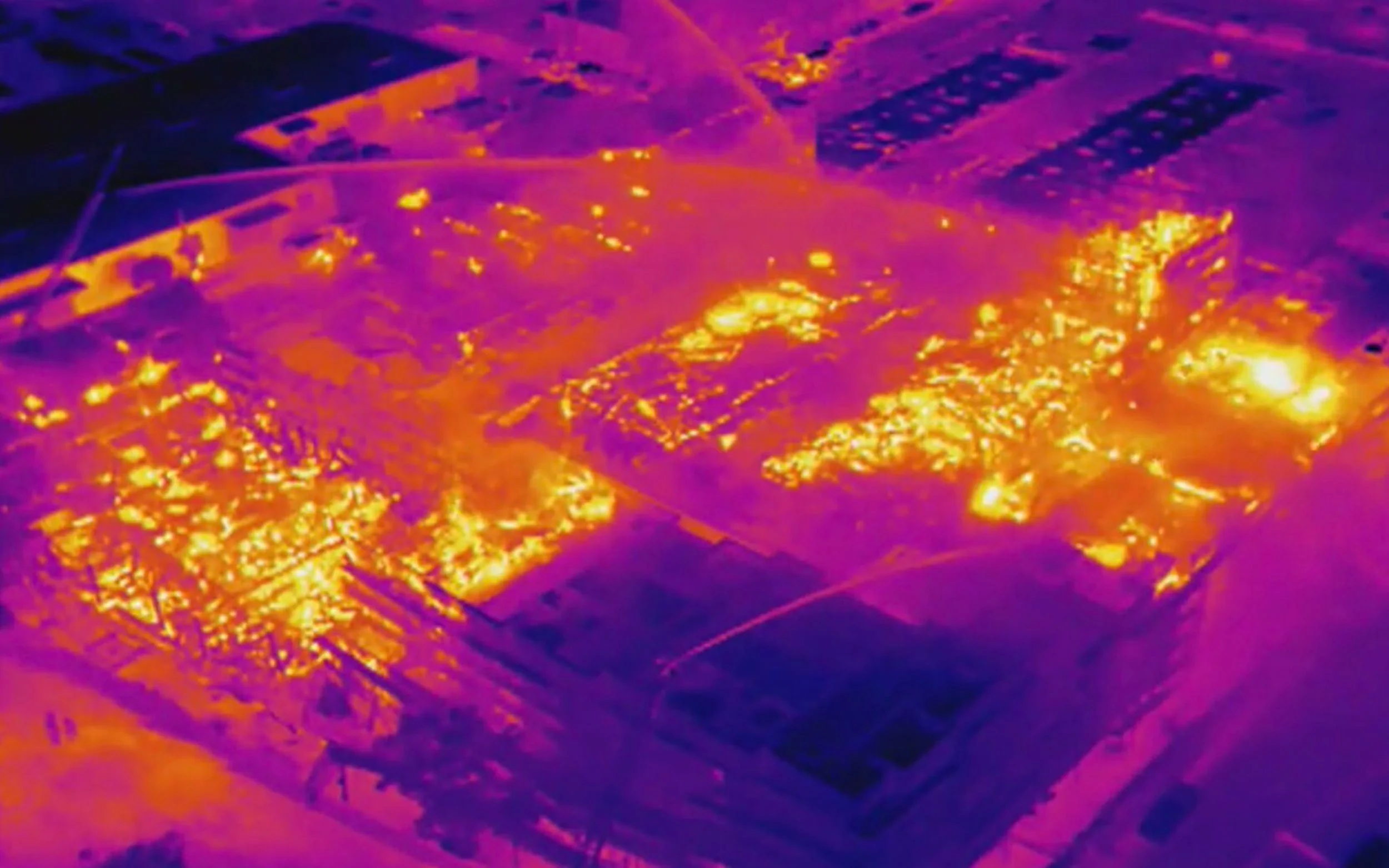
Drone with thermal camera shows hot spots in massive fire in Oakland, Calif.

Thermal Drone Image

Oakland firefighters have been battling a massive fire overnight at a construction site where townhomes are being built. The fire was reported at 2 a.m. this morning. About 90 firefighters were on the scene as the massive fire ripped through the townhouse construction site located at West Grant and Filbert Street in Oakland, Calif. The Alameda County sheriff’s deputies brought a DJI Inspire 1 in to get footage of the fire. The drone equipped with a thermal camera shows exactly where the hotspots are.

Drone with thermal camera deployed

According to Department chief Nick Luby, the fire went up so quickly because of the construction supplies.

“So basically it was just a big pile of kindling- 2×4’s and small timber and a lot of air in there and it can circulate and get the timber going real quick and then it grows quickly,” he said.

Power company PG&E shut down the power for about 2,200 customers as firefighters were battling the fire. Near Myrtle Street, about 30 homes were evacuated out of fear of the fire spreading.

A second fire starts in Oakland

Only a few blocks away at 3266 Peralta Street, another fire broke out at a residential construction site later this morning. According to the firefighters, it was a small fire that was already out by the time they arrived. However, they did see some suspicious looking evidence and called for investigators. In recent years more residential construction sites in Oakland have been going up in flames. Today’s two fires mark number six and seven and both are currently under investigation.

“In addition, we had a report of attempted arson at 3266 Peralta and so with that – we are on heightened alert and awareness to try to ensure that we do our due diligence to understand what happened here and whether or not the two incidents are related,” said Oakland Fire Chief Darin White according to ABC7News.

To assist the firefighters, the Alameda County sheriff’s deputies brought a DJI Inspire 1 drone in to get footage of the fire. The drone equipped with a thermal camera shows exactly where the hotspots are.

Drone Thermal video

In the video below you can see what the drone pilot saw on his screen. The thermal camera has a number of different ways in which the information can be displayed. Depending on the circumstances, certain settings may help the operator get a better understanding of what is happening on the ground. You can see the operator flick through the various options at about nine minutes into the video. The DJI Inspire 1 was flown by the Alameda County Sheriff’s Office and released by Alameda County Fire.

Video credit: Flown by Alameda County Sheriff’s Office and released by Alameda County Fire.

Sourced from: Drone DJ.

‘Pitch Night’ Winners

Written by Ryan Bentley of the Petoskey News Review.

HARBOR SPRINGS — Three recently launched Emmet County businesses received monetary boosts to help with growth and development efforts when selected as prize winners in Wednesday’s Emmet Entrepreneur Challenge.

Emmet Drones owner/operator Kurtis Damerow (second from left) displays the first prize of $7,750 which he won in Wednesday’s Emmet Entrepreneur Challenge. Pictured with him are fellow Petoskey Regional Chamber of Commerce Ambassadors Committee membe…

Emmet Drones owner/operator Kurtis Damerow (second from left) displays the first prize of $7,750 which he won in Wednesday’s Emmet Entrepreneur Challenge. Pictured with him are fellow Petoskey Regional Chamber of Commerce Ambassadors Committee members (from left) Tonya Fegan, Cindy Pasant and Tracey Dryovage.

This “pitch night” competition at the Lyric Theatre in Harbor Springs was geared toward operators of Emmet County-based businesses launched within the past two years, as well as prospective entrepreneurs intending to pursue a business concept locally. Organizers narrowed the field of applicants to 10 finalists — one of which dropped out of the competition — who were invited to make brief verbal pitches about their business models before a panel of judges and other interested community members.

The event’s prize winners included:

— Emmet Drones, a Petoskey venture owned and operated by Kurtis Damerow, which was awarded the event’s top prize of $7,750, as well as a three-month membership at The Loft Coworking Space in Harbor Springs and memberships in the Petoskey and Harbor Springs chambers of commerce. Damerow’s business offers services such as aerial photography, mapping and three-dimensional modeling, making use of unmanned aerial vehicle (drone) technology along the way

— Lakeshore Dry Goods, a Petoskey venture owned and operated by Pam and Christian Colby, which received the second prize of $3,000 plus a$251.50 people’s choice award determined by audience voting. The Colbys’ venture offers towels made from organic cotton, which are intended to provide a softness similar to that found in T-shirts and a more hair-friendly drying option

— Vine Ride, a Petoskey business owned and operated by Jeff Kozisek and Kassia Perpich, which took the third prize of $2,000. The business specializes in small-group tours of area wineries

Other entrepreneurs with business concepts or ventures featured in Wednesday’s pitch night included Scott Adams with Handy in Harbor, Rebecca Adams with Admired in Harbor, Joan Tiihonen with Bayfront Park Cafe, Alexis Fila with Beautiful Feet Dance Studio, Lisa Ernsberger with Healthy Human Oasis and Brett Behrendt with Orthoheat, whose business model was presented by Bill Mulder.

Georgia Abbott, a local business consultant serving on the Emmet Entrepreneur Challenge’s organizing committee, said providing outstanding business startups with resources to bolster their ventures was just one of the goals behind the event.

“It’s also a promotional event which tells the community about startups,” she said.

The Emmet Entrepreneur Challenge is one of four local-level pitch nights happening this year around the Northern Lakes Economic Alliance’s service region. The prize winners from the Harbor Springs event — along with high-ranking competitors from similar events in East Jordan, Cheboygan and Bellaire — receive invitations to vie for additional prizes at the regional “Grand Event” pitch night planned for Nov. 27 at the Great Lakes Center for the Arts in Bay Harbor.

Hannah Sanderson, a business attraction and growth specialist with Northern Lakes, noted that organizers were pleased with the level of interest the Emmet Entrepreneur Challenge drew when offered for the first time this year. She noted that premier sponsors Consumers Energy and the DTE Foundation played key parts in making the pitch nights around the region possible.

Other sponsors of the Harbor Springs event included the Petoskey-Harbor Springs Area Community Foundation, Northern Lakes Economic Alliance, Petoskey Regional Chamber of Commerce, Boyne Highlands Resort, Stafford’s Pier Restaurant, Harbor Brenn Insurance, Insurance by Burley, The Cottage Company of Harbor Springs &Cottage Company Interiors and First Community Bank.

Judges for Wednesday’s event included Carla Gribbs of DTE Energy, Tim Petroskey of Consumers Energy, Tyler Gostinger of Petoskey Brewing, Jennifer Shorter of Grandpa Shorter’s and Katie Potts of Petoskey Cheese.

Source

Surveying with Drones is a Game Changer for Real Estate Developers

Less Buck, More Bang

No developer can justify spending tens of thousands of dollars to stake acreage for development, or to commission aerial photography by plane, until the project feasibility is fully assured. But for a fraction of the cost of traditional survey means, developers can use drone services to survey a large land parcel to determine if it will fit their needs, before investors are even on board.

By Aavaaz home builder

By Aavaaz home builder

The envisioning stage of a project has always been hindered by reliance on old surveys or the lack of sufficient detail from aerial and satellite imagery. How much time and money do you tie up in an idea, to get to the stage of knowing it will be profitable? Drones now supply superior detail and accuracy up-front to identify more opportunities, and reveal more pitfalls, within an area.

While it now costs much less to survey specific parcels that a developer is interested in, using drones allows developers to take a deeper look at more parcels up-front. If you look at more parcels, you will always make a better land purchase. A drone can survey a 100-acre property in three days for a few thousand dollars.

One or two parcels thus become five or 10 properties under consideration. Big IS better when it means finding that perfect site for development. Using high-accuracy topography and orthomosaic maps from qualified drone companies can make this a reality.

The envisioning stage of every project involves a feasibility study across a number of fields, from funding to approval, to construction to ultimate return on investment. All the professionals involved in this process – from contractors to zoning boards, county authorities and local inspectors, and from investors to architects – will look at photographs first as the realistic view before moving on to any of the detailed drawings.

Drones can quickly and affordably fly over areas of varied terrain and capture potentially millions of data points for later software manipulation, all the while bringing back superb, high-resolution photographs that present all this data in a way that humans can immediately relate to.

Survey Accuracy

While drone affordability and rapid delivery time make drone surveys a game changer in the initial thinking and investment stages, the great feature of drone imagery lies in its accuracy, which benefits subsequent development work. Photographs and videos present a mass of data in a clear way, but engineers need drawings and measurements.

As planning evolves, the data returned from the initial drone survey can be overlaid into maps, topographic contour lines and even 3D models. These output files can be imported as shape-files, Autocad/DXF files and other industry-standard formats, integrating right into your existing workflow. Because the drone can fly close to the ground, and can maneuver dexterously around structures, true oblique imagery is returned showing side features that can’t be captured from higher above by satellite or plane.

Assuming the data commissioned is dense enough, drone survey images will be orthorectified to match not only their map coordinates but the elevations at each point also. Orthomosaic mapping results, with all images stitched into a coherent whole. Drainage and elevation calculations can be made from drawings all produced at scale across the parcel.

The great bonus of the drone is that its spectacular photography is also accurate enough to offer precise measurements, to within centimeters or finer. Many times, depending on the level of service commissioned, the exploratory survey data can be incorporated into the eventual construction work.

The Industry

The skill sets of a drone company and a survey firm are quite different, and as the field of drone surveying evolves, developers are using specialized drone service companies that also work extensively with surveyors. Piloting drones and investing in their rapid technological innovations typically takes a specialized drone company, while surveying is a professional skill. The two fields are synergizing well together, and real estate development loves it.

To gain a clear vision of our land we once had to go to the mountain top. Then we had planes, and then we had satellites, and now finally drones have supplied the missing piece of land development. Land surveying, and real estate developers, were always waiting for drones.

Sourced from: Drone Life

If you think Emmet Drones can help with your next project, let us know! We also love to hear from you if you found this article helpful or interesting.

Survey of Aggregate Quarry is Safer — and 20x Faster — Thanks to Drones

Hydrogeologist Uses Drone-Generated Maps and Models as Water Management Tool at Ontario Quarry

In the aggregate industry, water management and extraction from below the water table go hand in hand. If it isn’t managed well, surface water and groundwater can collect in the quarry and affect day to day operations. The aggregate industry usually relies on time-consuming ground surveys to gather the elevation data needed to make water-management decisions. Drone maps improve the development of the water management plans for quarries. By using drones to survey an Ontario aggregate quarry, Tecia White of Whitewater Hydrogeology Ltd. not only improved jobsite safety and gathered a richer set of data, but she did it all twenty times faster than a traditional ground survey.

Tecia White, President at Whitewater Hydrogeology Ltd.

Tecia White, President at Whitewater Hydrogeology Ltd.

Tecia White has over nineteen years of experience as a geologist and hydrogeologist. She spends most days solving hydrogeological challenges through her environmental consulting firm, Whitewater Hydrogeology Ltd. The firm primarily works with aggregate operators in southern Ontario to help them understand the influence of existing and proposed operations on the groundwater and surface water regimes. A little over a year ago, Tecia began offering a new service to Nelson Aggregate Co. and began incorporating drones into her work as a way to analyze stockpile volumes. But it wasn’t long before she discovered that drone maps and models could give her far more than just volumetric data. She tells the story of how she used drone-generated maps and 3D models as a tool for gathering elevation data and creating water management plans at Nelson Aggregate’s Uhthoff Quarry. Nelson Aggregate has also taken the use of the drone one step further by using it to inspect the operating condition of large production equipment.


Drone-Based Stockpile Analysis is “Miles Ahead of Standard Surveying”

As Tecia puts it, “Everyone should be using drones for stockpile analysis. It’s miles ahead of standard surveying.” Tecia would know. Over the past year, she has fired up her drone nearly a dozen times at six of Nelson Aggregate’s gravel pits and limestone quarries. What began as a way to inventory stockpile materials has quickly become a key tool in her everyday workflow.

Tecia spoke with us about the maps and models she created at the Uhthoff Quarry, which is owned and operated by Nelson Aggregate. The 1400 acre aggregate quarry supplies various limestone products to the construction industry. Over the past year, Tecia used her DJI Phantom 4 several times each season to map major stockpiles, then used DroneDeploy’s stockpile analysis app to inventory the materials. In a matter of minutes, she was able to measure the cut, fill and volume of any stockpile she mapped.

She also used DroneDeploy to conduct a complete aerial survey of the quarry multiple times throughout the year. From creating drainage and discharge plans, to estimating the volumes of overburden material that must be removed, Tecia used drone-generated data in nearly every aspect of her work at the quarry.

Hydrogeologist Tecia White used DroneDeploy’s stockpile analysis tool during her work at a southern Ontario aggregate quarry.

Hydrogeologist Tecia White used DroneDeploy’s stockpile analysis tool during her work at a southern Ontario aggregate quarry.


Aerial Surveys are Twenty Times Faster than Ground-Based Methods

Continual changes across the landscape of the quarry makes water management an ongoing process. At a site like the Uhthoff quarry, elevation data is usually gathered twice a year. But before drones entered the picture, this information could only be gathered by ground survey. It takes upwards of twenty man hours to survey and process data for a 1400 acre quarry. And even then, the survey would only gather the elevations of individual stockpiles, and occasionally spot elevations for the quarry floor.

An aerial survey of the Ontario site, on the other hand, takes Tecia just two hours to complete, including both flight time and data extraction. Tecia’s drone not only gathered accurate elevation data for the entire 1,400 acre site, but it did so twenty times faster than a ground-based survey of just individual stockpiles. This represents a far greater data set and a ninety-five percent reduction in man hours.

A ninety ninety-five percent man hour reduction is impressive enough, but the biggest return-on-investment can be seen by looking at time and money savings over all six of Nelson Aggregate sites. A bi-annual survey of six quarry sites represents about 240 man hours. Compare that to just twelve hours needed to complete twice-yearly aerial surveys at all six sites. That’s a savings of 228 man hours.

In terms of money savings, the results are no less impressive. Nelson Aggregate spends about $3,000 to subcontract out a single ground survey. Bi-annual ground surveys of all six quarries cost around $36,000 total per year. Factoring in drone equipment and software subscriptions, the same amount of aerial surveys cost just $7,500 — $28,500 less than a ground survey. This represents nearly 80% in costs savings.

By replacing ground-based surveys with bi-annual aerial surveys, Nelson Aggregate saved a total of 228 man hours and $28,500 across six quarry sites.


Drones Improve Worker Safety at Aggregate Operations

With steep slopes, unstable rock faces and lots of heavy machinery, rock quarries can be dangerous places to work. Aggregate operators are always looking at field methods to improve the safety of the work environment. As Tecia sees it, one of the greatest benefits of drones is their ability to improve worker safety by removing the requirement to have men on the ground in and around the operation areas (stockpiles, equipment).

“Anytime you can reduce the number of workers in a quarry it is going to reduce the chance of injury and improve overall safety,” — Tecia White, Whitewater Hydrogeology Ltd.

Instead of spending twenty hours navigating stockpiles and quarry terrain to complete a ground survey, flights are launched outside of the operating quarry and pit working areas. All of the elevation data needed for the Ontario site is now gathered without ever setting foot within the operation. This improvement alone is worth the investment in drone technology.

“Anytime you can reduce the number of workers in a quarry it is going to reduce the chance of injury and improve overall safety,” says Tecia. “Drones allow us to do that.”


Drone Maps and Models Give Hydrogeologist a Rich Data Set

Although Tecia first set out to gather elevation data and stockpile information, she soon discovered that her drone provides a rich set of data that is useful in many other aspects of quarry management. “With a surveyor you’re just getting the data,” says Tecia. “There are no maps or models.”

Now, with the help of DroneDeploy, Tecia uses her drone maps for far more than elevation data and stockpile analysis. With accurate drone maps, DroneDeploy’s built-in volume tool is used to estimate the amount of overburden material that must be removed prior to the extraction of aggregate. High-resolution 3D models allow her to remotely assess progressive and final rehabilitation work. She also uses the models to conduct aerial circle checks of heavy machinery, searching for issues that would not be visible from the ground.

Speaking to others who work in hydrogeology and quarry management, Tecia has these words of encouragement about using drones: “Embrace the change and move forward. This technology is working.”

Sourced from: DroneDeploy.


If you think Emmet Drones can help with your next project, let us know! We also love to hear from you if you found this article helpful or interesting.